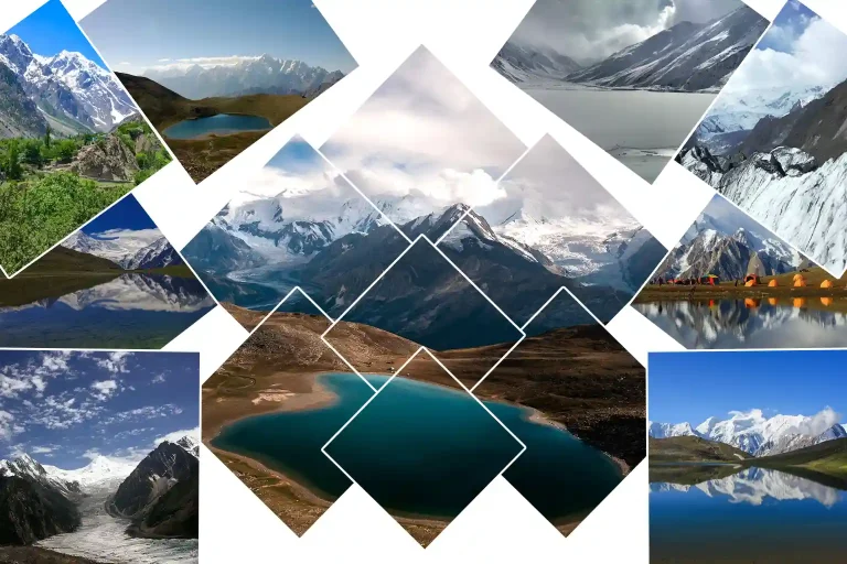
Rush Lake is a trek, not a drive. The trail from Hopar climbs steadily into the high country, villages fall behind, and the familiar green of Nagar gives way to rock, ice, and open alpine slopes. There is no road beside the lake and no resort at the shore.
At around 4,694 metres, Rush Lake sits in a high basin surrounded by the Karakoram, and reaching it means several days of mountain terrain with glacier sections and high camps. That effort is part of the experience. It is a multi-day high-altitude best done in July or August with an experienced local team.
This guide covers where the lake sits, the route from Hopar, difficulty, best months, what to do there, what to pack, and how to reach it. The reward is a quiet alpine lakes with views toward some of the major peaks of the Nagar and Karakoram landscape, from Spantik to Malubiting.
Quick Facts About Rush Lake
| Location: | Nagar Valley, Gilgit-Baltistan. |
| Area: | Hopar region; Hopar is the trekking base. |
| Elevation: | About 4,694 metres; one of the highest alpine lakes in the world. |
| Lake type: | High-altitude alpine and glacial lake. |
| Access: | Multi-day trek; no road reaches the lake. |
| Nearby high point: | Rush Peak, about 5,098 metres. |
| Landscape: | Glaciers, Alpine slopes, and Karakoram peaks. |
| Main trekking season: | June to September. |
| Accommodation: | Camping along the trekking route. |
Where Is Rush Lake Located?
Rush Lake is in the Nagar Valley region of , around the Hopar area. The lake lies deep inside the Karakoram, far above the settled valley and away from regular road access. It is not a destination you reach by driving closer and walking a few minutes; you have to enter the mountains.
Hopar is the practical starting point for the trek. From there, the route moves through increasingly remote terrain tied to the area’s glaciers and high mountain valleys. The side you start from and the camps you use shape the whole journey.
From Gilgit to Nagar
Travellers heading toward Rush Lake normally make their way from Gilgit toward Nagar, then continue to Hopar by road. Keep this leg flexible, because road, weather, and transport conditions in northern Pakistan can change without much notice.
From Hopar to the High Country
Hopar marks the transition from road travel to trekking. The route climbs through rough terrain, glacier country, and alpine camps before reaching the lake basin. Published itineraries differ in their exact camp names and daily distances, so confirm the current route locally before departure.
How Remote Is Rush Lake?
The lake is remote enough that there are no conventional hotels, restaurants, or roadside facilities at the destination. That means you plan for the following.
Camping: overnight stays are normally in trekking camps.
Food: meals and supplies need organising before and during the trek.
Guides: local trekking support is valuable, particularly around glacier terrain.
Weather: itineraries should allow room for delays and route changes.
Altitude: the final approach takes place at nearly 4,700 metres.
The Landscape Around Rush Lake

Rush Lake sits in an alpine environment shaped by elevation, snow, and glacial activity. Trees disappear from the immediate landscape, replaced by rocky ground, grassy high slopes, snow patches, and broad mountain basins. Against that harsher setting, the lake itself can look surprisingly calm.
On a clear day, its blue surface contrasts with muted brown and green slopes before the view rises toward larger snow-covered peaks. When the wind drops, reflections appear across the water and give the lake a much stronger sense of depth. The surroundings matter as much as the water.
An Alpine Basin
The lake occupies a high mountain basin rather than a developed lakeside setting. There are no paved paths around the shoreline, and that openness is a large part of what makes Rush Lake different from the easily accessible lakes elsewhere in Pakistan.
Glacier Country
The wider trekking environment includes the Miar Glacier and the Hopar and Bualtar glacier systems, depending on the route. Glacier crossings are one reason the trek should not be treated as an ordinary trail. Surfaces and conditions change, and routes that look straightforward in photographs may need local knowledge.
The View Changes With the Weather
High-altitude weather transforms the landscape quickly. A clear view of the surrounding peaks may cloud over within minutes, and a ridge can vanish behind mist while the lake stays completely visible. For photographers this is frustrating; for trekkers it is simply part of the mountain experience.
The Karakoram Views From Rush Lake
The lake’s elevated position gives it a broad mountain backdrop, with views commonly associated with peaks including Spantik or Golden Peak, Malubiting, Miar Peak, and Phuparash. Spantik stands out in the wider panorama, while the nearby peaks and glacier systems make the view feel connected to the whole landscape rather than a single isolated summit.
The best views depend heavily on visibility. An early morning with clear skies can reveal distant peaks in sharp detail, while later in the day cloud can soften or hide sections of the skyline. That is why a night at the lake is worthwhile even when the first view is not perfect: the mountains get another chance the next morning.
Trekking to Rush Lake
The journey to Rush Lake is the main attraction for many visitors. It is a multi-day high-altitude adventure that begins around Hopar and moves progressively farther into the mountain landscape. Exact itineraries vary, but the route generally combines village approaches, steep sections, glacier terrain, and high camping areas.
Hopar and the First Trekking Sections
The trek starts from the Hopar area and quickly leaves normal road access behind. The lower part of the route can feel more open and familiar, but the landscape becomes increasingly rugged as elevation rises. This is the stage where pacing matters most; it is easy to walk too quickly early and pay for it later.
Glacier Sections
The route can involve glacier crossings linked to the surrounding Miar and Bualtar landscape. These sections require more care than ordinary trail walking. A guide who knows the current route makes a major difference, especially when glacier conditions have changed since previous seasons.
The Final Approach
As the trek climbs toward the lake, the surroundings become more alpine and exposed. Vegetation thins, the path feels less defined, and the distant peaks start to dominate the view. Then the lake appears. For many trekkers that first sight is the defining moment of the route, not because the lake is enormous, but because of where it appears: after days of walking, above the valley, with the Karakoram spread behind it.
How Difficult Is the Rush Lake Trek?
Rush Lake is best considered a moderate-to-challenging high-altitude trek. The biggest challenge is the combination of altitude, multi-day walking, cold conditions, remote terrain, and possible glacier crossings. Difficulty also varies between trekkers: a well-trained hiker may find the walking manageable but struggle with altitude, while another may be comfortable at elevation but find glacier terrain unfamiliar.
What Makes It Challenging?
- High elevation: the lake is at roughly 4,694 metres.
- Long walking days: several consecutive trekking days are involved.
- Glacier terrain: some routes include glacier crossings.
- Cold nights: temperatures can drop significantly at camp.
- Remoteness: services become very limited once you leave the villages.
- Weather: conditions can change quickly in the mountains.
Who Should Consider the Trek?
Rush Lake suits trekkers who are prepared for several days in the mountains and understand that altitude can affect even fit travellers. People with no previous trekking experience should prepare carefully rather than assuming ordinary fitness is enough. Long uphill walks, stair training, weekend hikes, and carrying a loaded backpack are all useful preparation.
Best Time to Visit Rush Lake

The main trekking season is June through September, with July and August the most practical months for a standard Rush Lake journey. Here is what each part of the season is like.
June
- Conditions: snow may remain on higher sections.
- Best for: experienced trekkers seeking an earlier-season landscape.
- Watch for: less predictable conditions.
July to August
- Conditions: core summer trekking window.
- Best for: standard Rush Lake trekking.
- Highlight: better chance of accessible routes and clear alpine scenery.
September
- Conditions: cooler and generally quieter.
- Best for: trekkers who prefer fewer people and crisp conditions.
- Watch for: colder nights and late-season weather.
Winter
- Conditions: heavy snow and severe cold make normal access impractical.
- Best for: specialist mountain expeditions.
- Watch for: difficult route and access conditions.
What to Do at Rush Lake

Rush Lake is not surrounded by commercial attractions. The experience comes from the landscape itself, and the best activities are simple: camp, photograph, explore the high country, and give the mountains time to reveal themselves.
Camp Beside Rush Lake
Spend a night in the high alpine basin and experience the lake after sunset and before the trekking day begins.
- Best for: overnight trekking.
- Best season: June to September.
- Tip: camp for sunrise and early-morning mountain views.
Photograph the Lake
Rush Lake is ideal for wide mountain landscapes, reflections, and glacier scenery. Early morning usually offers the calmest water and the clearest distant peaks.
- Best for: landscape photography.
- Best time: early morning.
- Tip: use the lake as foreground for the surrounding Karakoram peaks.
Hike Toward Rush Peak
Rush Peak rises to about 5,098 metres and is closely associated with the lake. Some trekking programmes include an additional hike or summit attempt after reaching Rush Lake.
- Best for: experienced trekkers.
- Altitude: about 5,098 metres.
- Tip: treat the summit as a separate high-altitude objective.
Watch the Mountain Weather
Clouds cover distant peaks, sunlight moves across the slopes, and the colour of the lake shifts through the day. At Rush Lake, waiting is part of the experience.
- Best for: scenic views and photography.
- Tip: allow time for changing visibility.
Planning the Rush Lake Trek
Rush Lake is easier to enjoy when the trip is planned around the mountain rather than a rigid timetable. Confirm current route conditions locally and leave room for weather or slower trekking days.
Plan Before You Start
Confirm current route conditions before departure.
Arrange an experienced local guide or trekking team, especially for glacier terrain.
Build acclimatisation time into the itinerary rather than gaining height too quickly.
Keep buffer time between the trek and onward transport.
Prepare for cold nights with suitable layers, a sleeping bag, and weatherproof equipment.
Pack Essentials
- Trekking boots with good grip
- Warm base and insulation layers
- Waterproof and windproof outer shell
- Gloves, hat, and warm socks
- Sunglasses and sunscreen
- Cold-rated sleeping bag
- Trekking poles and headlamp
- Water bottles or hydration system
- Personal first-aid supplies
- Power bank and high-energy snacks
- Waterproof bags for electronics and clothing
Getting to Rush Lake From Islamabad
For travellers starting in Islamabad, reaching Rush Lake combines road or air travel with a multi-day trek. Once you reach Hopar, the vehicle journey ends and the rest is on foot. The route breaks into three stages.
Road or Air: Islamabad to Gilgit, by flight when operating or by road on the Karakoram Highway.
By Road: Gilgit to Nagar, then on to Hopar, where the trek begins.
By Trek: Hopar on foot through glacier country and high camps to Rush Lake.
Northern road and flight schedules can be affected by weather and local conditions, so a Rush Lake itinerary should always include buffer time.
Top Places Around Rush Lake

Rush Lake works well as part of a wider Nagar Valley and Gilgit-Baltistan journey. Treat these as highlights around the trek rather than a separate sightseeing circuit.
Rush Peak
A nearby high-altitude summit rising to about 5,098 metres, often included as a separate trekking objective after the lake.
Hopar Valley
Hopar Valley is the practical trekking gateway, with views into the region’s glacier landscape before the route enters the higher country.
Miar Glacier
Miar is a major glacier feature associated with the wider mountain environment around the Rush Lake approach.
Bualtar Glacier
Bualtar Galcier is a part of the glacier terrain linked with the Hopar side of the trekking landscape.
Spantik / Golden Peak Views
One of the notable mountain panoramas associated with the wider Rush Lake and Nagar landscape.
Nagar Valley
Nagar valley is the broader regional setting for the trek, with villages, mountain slopes, and glacier scenery.
Hunza
Hunza valley is a natural add-on for travellers building a longer Gilgit-Baltistan journey before or after the trek.
Where to Stay Before the Trek
There is no conventional accommodation beside Rush Lake. The practical options are split between the lower settlements and the trekking route itself, so arrange your overnight logistics before you begin.
- Before the trek: stay around Hopar or another suitable base in Nagar.
- During the trek: use organised camps.
- At the lake: expect a tent rather than a hotel room.
- After returning: continue to accommodation in Nagar, Hunza, or Gilgit depending on your itinerary.
Rush Lake Safety Tips
High altitude changes the way you need to travel. The most important safety principles are simple, and they matter more here than the walking itself.
- Take altitude seriously: do not ignore headache, nausea, dizziness, or unusual fatigue.
- Ascend gradually: give your body time to adjust.
- Do not rush: a sustainable pace beats an impressive first-day distance.
- Follow local glacier guidance: never assume a crossing is safe because an old report said so.
- Watch the weather: be prepared to delay or change the day’s route.
- Carry sufficient layers: conditions turn cold very quickly after sunset.
- Stay with your group: remote terrain is not a place to wander off the route.
- Keep emergency flexibility: extra time is part of a good itinerary.
Responsible Travel Around Rush Lake
Rush Lake is a high-altitude natural environment with very little infrastructure, which makes responsible travel especially important. The quieter and cleaner the landscape stays, the better.
Carry all waste back down; leave no plastic, packaging, or rubbish at camps or the lake.
Avoid damaging alpine vegetation and use existing camping areas where practical.
Minimise disturbance to the surrounding landscape and wildlife.
Support local guides, porters, and community trekking services to keep income in the region.
Is Rush Lake Worth the Trek?
Rush Lake is not an easy-access destination, and that is exactly what defines it. The attraction is not a lakeside restaurant or a crowded viewpoint. It is the combination of a high alpine lake, glacier terrain, multi-day trekking, and broad Karakoram scenery.
Add Rush Peak, views toward peaks such as Spantik and Malubiting, and nights spent camping in the high country, and the experience becomes much larger than a simple lake visit. You earn the view, and that changes how you remember it. For another lake that rewards the same kind of effort, see .
Conclusion
The approach to Rush Lake is part of what makes the destination memorable. You leave Hopar and gradually enter a landscape where roads disappear, glaciers come closer, and the mountains take over the horizon. By the time the lake appears, you have already crossed much of the landscape that gives it meaning.
Then there is the water: blue, quiet, and surrounded by the high Karakoram at roughly 4,694 metres. Rush Lake does not offer the easiest view in northern Pakistan. It offers the kind you have to walk for, and for travellers ready for that effort, the lake becomes the place where the trail, the glaciers, and the mountains finally come together.
Plan your trek around the season, current route conditions, and proper acclimatisation, then let the mountain set the pace. For more high-altitude destinations, explore the and start planning your journey into Nagar’s high country.
Frequently Asked Questions
1. Where is Rush Lake located?
Rush Lake is in the Nagar region of Gilgit-Baltistan, near the Hopar area of Nagar Valley. The lake sits deep in the Karakoram at an elevation of about 4,694 metres.
2. How high is Rush Lake?
Rush Lake is approximately 4,694 metres above sea level. Its high elevation is one reason it is widely described as one of the world’s highest alpine lakes.
3. How do you reach Rush Lake?
The usual approach begins around Hopar in Nagar and continues on foot through high-altitude mountain terrain. Depending on the route, trekkers may cross glacier sections before reaching the lake basin.
4. How many days are needed for the Rush Lake trek?
The exact duration varies by itinerary, route, and pace. The journey is normally planned as a multi-day trek with camping, rather than a one-day hike.
5. What is the best month to visit Rush Lake?
July and August are generally the most practical months. June can still have snow at higher elevations, while September brings colder nights and later-season weather.
6. Is Rush Lake suitable for beginners?
It can be possible for well-prepared beginners with proper support, but it is not an easy introductory hike. The elevation, camping, long walking days, and possible glacier crossings all make preparation important.
7. Is there a hotel at Rush Lake?
No conventional hotel or resort is located beside the lake. Trekkers normally stay in tents at camps along the route.
8. Can you climb Rush Peak from Rush Lake?
Rush Peak is about 5,098 metres high and is a separate trekking objective near the lake. Some itineraries include an additional hike or summit attempt after reaching Rush Lake.
9. What should I pack for Rush Lake?
Warm layered clothing, strong trekking boots, a suitable sleeping bag, waterproof outerwear, trekking poles, sun protection, a headlamp, personal first-aid supplies, and enough food and water equipment are among the main essentials.
10. Is Rush Lake difficult to trek?
It is generally a moderate-to-challenging high-altitude trek. The difficulty comes from elevation, multi-day walking, cold conditions, remote terrain, and glacier sections rather than from one single technical climb.
