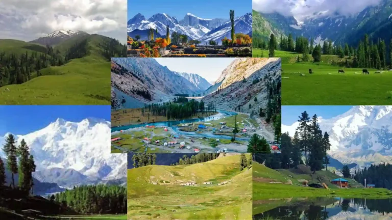
From the cultivated terraces of Hunza to the forested river corridor of Neelum, Pakistan’s valleys change character quickly as you move across the country. Some are narrow mountain passages cut by rivers and glaciers. Others open into broad basins where villages, orchards and farmland occupy the flatter ground between surrounding ranges.
In the north, the Karakoram, Himalaya and Hindu Kush create the country’s largest concentration of high mountain valleys. Farther south, the landscape changes into Salt Range basins, dry Balochistan highlands and river-cut terrain along the Indus and Kirthar ranges.
Among the best-known valleys of Pakistan are Hunza Valley, Neelum Valley, Naran-Kaghan Valley, Swat Valley, Kumrat Valley and Astore Valley.
This guide looks at those valleys as landscapes rather than as interchangeable tourist destinations: where they sit, how the terrain changes, what shapes them, and how they connect with the wider geography of Pakistan.
Valleys of Pakistan at a Glance
| Region | Notable Valleys | Landscape Character |
|---|---|---|
| Gilgit-Baltistan | Hunza, Gojal, Astore, Shigar, Khaplu, Phandar, Naltar | Karakoram and Himalayan valleys, glacier-fed rivers, high peaks and cultivated terraces |
| Khyber Pakhtunkhwa | Naran-Kaghan, Swat, Kalam, Kumrat, Chitral, Kalash | Forested valleys, alpine lakes, high pastures and Hindu Kush or Himalayan terrain |
| Azad Jammu & Kashmir | Neelum, Leepa, Jhelum Valley | River corridors, forested slopes and Himalayan mountain settlements |
| Punjab | Soon Valley and smaller hill or river valleys | Salt Range basins, lakes, hills and lower-elevation river landscapes |
| Balochistan | Quetta, Urak, Zhob, Loralai and other highland valleys | Dry mountain basins, orchards, plateaus and seasonal waterways |
| Sindh | Indus river corridor and valleys within the Kirthar landscape | River plains, dry mountain valleys and desert-edge terrain |
How Pakistan’s Valleys Are Distributed
A valley in Pakistan does not always look like the familiar green mountain corridor seen in tourism photographs.
In the far north, rivers and glaciers have cut deeply between some of the world’s highest mountain systems. Settlements often occupy terraces above the rivers because level ground is limited. Roads follow the same natural corridors, squeezed between water below and rock walls above.
Move into the wetter Himalayan areas of Khyber Pakhtunkhwa and Azad Jammu & Kashmir and the slopes become more heavily forested. Rivers remain central to the geography, but pine-covered mountains, side streams and high pastures create a different valley character.
Farther south, valleys become wider and drier. Punjab’s Salt Range contains basins and lower hill valleys, while Balochistan has broad highland depressions surrounded by dry mountain ridges. Sindh’s valley landscapes are tied more closely to the Indus and the broken terrain of the Kirthar Range.
Valleys of Gilgit-Baltistan

In Gilgit-Baltistan, valleys are the spaces where life fits between the mountains.
Roads, villages, orchards and cultivated terraces follow narrow strips of usable ground beside rivers. Above them, barren rock, glaciers and high peaks rise quickly, giving each valley a strong sense of vertical scale.
Hunza Valley
Hunza Valley is easiest to understand by following the Hunza River north. Settlements such as Aliabad, Karimabad and Ganish sit on cultivated terraces above the water, while steep mountain faces rise behind them.
Around central Hunza, orchards, old villages and historic forts occupy the same slopes. Continue north and the valley gradually changes again, opening toward the higher and more exposed landscapes of Gojal.
Gojal Valley
Gojal Valley, often called Upper Hunza, feels more open and severe than central Hunza. The Karakoram Highway passes through Gulmit and Passu before continuing toward Sost and Khunjerab.
Here the landscape is shaped by broad river terraces, glaciers, exposed rock and sharp mountain forms. Attabad Lake introduces another feature entirely: a long body of blue water sitting directly inside the upper valley corridor.
Astore Valley
Astore Valley turns away from the main Gilgit corridor into a landscape of forest, open pasture and high mountain routes.
Lower sections contain villages and cultivated ground, while side roads climb toward Rama and other alpine areas. As elevation increases, the valley feels less like a single corridor and more like a network of side valleys, meadows and mountain approaches connected with the wider Nanga Parbat region.
Shigar Valley
Leaving Skardu for Shigar Valley, the landscape quickly changes from the broad Indus basin into a more enclosed river valley.
In the lower section, villages, orchards and cultivated terraces line the Shigar River. Shigar Fort and the surrounding old settlement give the valley a strong human layer, while farther north the landscape becomes increasingly rugged as the route continues toward Askole and the high Karakoram.
Khaplu Valley
Khaplu Valley sits along the Shyok River corridor east of Skardu. The river spreads through a wide mountain landscape where villages and orchards occupy the more forgiving ground between dry slopes.
Khaplu town adds another dimension through its old settlement and palace, making this one of the places where Baltistan’s landscape and built heritage are closely tied together.
Phandar and Naltar
Phandar Valley has a noticeably softer shape than many of the harsher Karakoram valleys farther east. The river winds through broader ground, with cultivated fields and villages spread along the valley floor and lower slopes.
Naltar Valley, closer to Gilgit, feels much narrower. Forested slopes close around the road as it climbs away from the larger Gilgit basin into the side valley.
Valleys of Khyber Pakhtunkhwa

The valleys of Khyber Pakhtunkhwa cover several different mountain environments.
Kaghan follows a Himalayan river corridor toward high alpine terrain. Swat and Kalam combine forest, rivers and inhabited mountain basins. Kumrat narrows into dense deodar forest, while Chitral reaches deep into the Hindu Kush.
Naran-Kaghan Valley
Naran-Kaghan Valley develops around the Kunhar River. In the lower valley, settlements and forested slopes sit close to the road. Higher up, the trees begin to thin and the landscape opens into alpine ground.
Continue beyond Naran toward Batakundi and the upper valley and the change becomes clearer: settlements grow smaller, slopes become more exposed, and the road climbs toward the high country around Babusar.
Shogran sits on a separate elevated shelf above the main Kaghan corridor. For that landscape specifically, see our Shogran Valley guide.
Swat and Kalam
Swat Valley is not one narrow mountain passage. It is a large inhabited river system with towns, farmland, archaeological sites and mountain landscapes extending far into Upper Swat.
By the time the road reaches Kalam Valley, the terrain has become more enclosed. The Ushu and Utror rivers meet here to form the Swat River, while roads branch into side valleys, forest and higher alpine areas.
Kumrat Valley
Kumrat Valley is defined by the relationship between the Panjkora River and the deodar forest rising around it.
Beyond Thal, the route becomes rougher and the built landscape begins to thin. The river stays close, forest occupies much of the valley floor and lower slopes, and open camping areas appear between trees and water.
That gives Kumrat a different character from more developed mountain corridors such as central Swat or Naran.
Chitral Valley
Chitral Valley stretches through the Hindu Kush along the Chitral River system.
Rather than one isolated destination, it works as a long geographic spine. Chitral Town sits within the central valley, while roads branch toward Garam Chashma, Upper Chitral and numerous smaller side valleys.
Dry mountain walls, river terraces and irrigated settlements give the wider Chitral landscape a character distinct from the greener valleys farther east.
Kalash Valleys
The Kalash Valleys are a group of side valleys within the wider Chitral region rather than one single valley.
Bumburet, Rumbur and Birir are the best-known. Settlements sit along narrow valley floors and lower slopes, with cultivated terraces and mountain sides rising around them.
The landscape is important, but so is the continuity of Kalash community life within it. Here, geography and culture cannot easily be separated.
Valleys of Azad Jammu & Kashmir

In Azad Jammu & Kashmir, rivers often provide the clearest way to read the landscape.
Roads follow water through narrow Himalayan corridors while villages occupy terraces, small flats and slopes above the river. Forest cover is heavier than in much of Gilgit-Baltistan, giving these valleys a noticeably different texture.
Neelum Valley
Neelum Valley is a valley you understand by following its river.
From the lower reaches beyond Muzaffarabad, the road remains close to the Neelum River while forested slopes rise on both sides. Settlements such as Keran and Sharda sit along the corridor, and farther north the mountains close in more tightly around Kel and the upper valley toward Taobat.
Side valleys, streams and high meadows extend away from the main road, but the river remains the geographic thread connecting much of the valley.
Leepa and Jhelum Valleys
Leepa Valley lies east of the main Jhelum Valley corridor. Terraced villages occupy the valley slopes and floor, while forested mountains rise closely around the cultivated ground.
Jhelum Valley follows a broader river corridor east of Muzaffarabad, connecting settlements along a landscape shaped by both the river and surrounding Himalayan foothills.
Valleys of Punjab

Punjab’s valley landscapes sit at a lower scale than the high mountain corridors of the north.
Here, the most clearly defined examples occur around the Salt Range and northern hill systems, where basins, rivers and surrounding ridges create smaller but distinct valley environments.
Soon Valley
Soon Valley in Khushab District is one of Punjab’s clearest named valley regions. The valley sits within the Salt Range, where lakes, villages and cultivated ground lie between surrounding hills.
Uchhali and Khabikki add open water to the landscape, while Sakesar rises above the wider valley. The result feels very different from the steep river-cut valleys of northern Pakistan: broader, lower and more open.
Other Valley Landscapes in Punjab
The Soan River, Potohar Plateau, Murree hills and Kotli Sattian contain numerous river cuts, basins and smaller hill valleys.
They should not, however, all be treated as equivalent to large named mountain valleys such as Hunza or Neelum. This difference in scale matters when describing Pakistan’s geography accurately.
Valleys of Balochistan

Balochistan changes the idea of a Pakistani valley again.
Instead of glacier-fed rivers and dense forest, many valleys here are broad dry basins enclosed by bare mountain ranges. Settlements, orchards and cultivated land tend to gather where groundwater, springs or seasonal drainage make agriculture possible.
Quetta and Urak
The Quetta basin sits inside a ring of mountains, giving the city and its surrounding settlements a clearly enclosed highland geography.
Nearby Urak Valley narrows into the mountains and is known for orchards and cultivated ground. The contrast between dry surrounding ridges and productive valley floor is characteristic of many inhabited landscapes in northern Balochistan.
Zhob, Loralai and Ziarat Highlands
Zhob and Loralai occupy broad highland valley and basin landscapes in northeastern Balochistan.
Around Ziarat, the elevation increases and the surrounding hills support Pakistan’s well-known juniper forest landscape. Valleys here feel more open and arid than those of the Himalaya, but they remain equally important corridors for settlement and movement.
Other famous Balochistan landscapes such as Hingol National Park and Moola Chotok are better described as national park, canyon or gorge landscapes rather than being grouped loosely as valleys.
Valley Landscapes of Sindh

Sindh is dominated by the Indus plain, so its geography cannot be described through mountain valleys in the same way as Gilgit-Baltistan or Khyber Pakhtunkhwa.
Here, the strongest valley relationships appear along the Indus river system and within the dry, broken terrain of the Kirthar Range in western Sindh.
Indus River Corridor
The Indus crosses Sindh as a broad river system surrounded by floodplain, agricultural land and long-established settlements.
The term Indus Valley is widely used in geographic and historical contexts, but this is a vast river region rather than a narrow mountain valley enclosed by steep slopes.
Kirthar Landscape
Along the western edge of Sindh, the Kirthar Range breaks the flatter landscape into dry ridges, gorges and seasonal drainage valleys.
These corridors are far more arid than Pakistan’s northern valleys and show how dramatically the form of a valley changes with geology and climate.
Choosing a Valley by Landscape and Travel Style
Instead of asking which valley is simply the “best,” it is more useful to ask what kind of landscape you want to explore.
| If You Want | Consider | What Defines It |
|---|---|---|
| Karakoram scenery and historic settlements | Hunza | Terraced villages, old forts, river views and steep mountain walls |
| Glaciers and a high frontier road | Gojal | Passu, glaciers, Attabad Lake and the upper Karakoram Highway |
| A long forested river corridor | Neelum | River, forested slopes, mountain settlements and side valleys |
| Alpine lakes and high mountain roads | Naran-Kaghan | Kunhar River, high lakes, alpine ground and the road toward Babusar |
| Dense forest and river landscapes | Kumrat | Deodar forest, the Panjkora River and rougher mountain access |
| Heritage within a Baltistan valley | Shigar or Khaplu | River valleys, orchards, old settlements, forts and palaces |
| Hindu Kush geography and culture | Chitral and the Kalash Valleys | Mountain corridors, side valleys and distinct settlement cultures |
| Alpine landscapes around the Nanga Parbat region | Astore | Forest, open pasture, side valleys and high mountain approaches |
Why Valleys Matter in Pakistan
Look at where Pakistan’s mountain communities are built and the importance of valleys becomes obvious.
Between steep ridges and high peaks, valley floors and river terraces often provide the ground where roads can pass, villages can expand and crops can grow. Water moving through these corridors supports agriculture and links settlements that would otherwise be separated by difficult mountain terrain.
Valleys also shape identity. Language, architecture, farming, food and settlement patterns can change from one valley to the next even when the distance between them is relatively small.
That is why exploring Pakistan valley by valley often reveals more about the country than treating the entire north as one mountain destination.
Frequently Asked Questions
How many valleys are there in Pakistan?
There is no single authoritative national count of Pakistan’s valleys. The number depends on how major river valleys, side valleys, mountain basins and locally named areas are classified. Pakistan contains many large named valleys as well as numerous smaller side valleys and drainage systems.
What are the most famous valleys in Pakistan?
Some of the best-known include Hunza, Neelum, Naran-Kaghan, Swat, Kalam, Kumrat, Astore and Chitral. Shigar, Khaplu, Gojal, Phandar and the Kalash valleys are also important mountain-valley destinations.
Which is the best valley in Pakistan?
There is no single best valley because each landscape offers something different. Hunza combines Karakoram scenery with historic settlements, Neelum follows a long forested river corridor, Naran-Kaghan climbs toward alpine lakes and high roads, while Kumrat is closely associated with forest and the Panjkora River.
Which part of Pakistan has the most high mountain valleys?
Gilgit-Baltistan and northern Khyber Pakhtunkhwa contain the country’s largest concentration of major high mountain valleys because the Karakoram, Himalaya and Hindu Kush converge across northern Pakistan.
What is the difference between a valley, meadow and hill station?
A valley is a lower area between surrounding higher ground, often shaped by a river or glacier. A meadow is an area of open grassland and may lie inside a valley or on an elevated mountain shelf. A hill station is a settlement or resort area at elevation and is not automatically a valley.
What is the best time to visit Pakistan’s valleys?
There is no single travel season for every valley. Elevation, snowfall, monsoon patterns and road conditions vary considerably between regions. High northern valleys and lower valleys can have very different access conditions at the same time of year, so current local conditions should be checked for the specific destination.
Where can I read detailed guides to individual valleys?
Nature Explorer has dedicated guides for major valley entities including Hunza, Neelum, Naran-Kaghan, Astore, Shigar, Khaplu, Gojal, Kumrat, Kalam and Chitral.
Exploring Pakistan Valley by Valley
Pakistan’s valleys cannot be reduced to one image of green slopes beneath snowy peaks.
Hunza is shaped by terraces, river and exposed Karakoram rock. Neelum follows water through forested Himalayan mountains. Kumrat closes around river and deodar forest. Astore opens into alpine side valleys, while Balochistan replaces glaciers and pine with broad dry basins and bare mountain ridges.
That variety is what makes the valleys useful as a way of understanding Pakistan itself.
Start with the wider landscape here, then move into the dedicated valley guides to explore each region in more detail: its geography, settlements, rivers, seasons, access and the smaller landscapes contained within it.

One thought on “Valleys of Pakistan”
非常有用的 旅行项目, 保持 保持节奏。衷心感谢!